
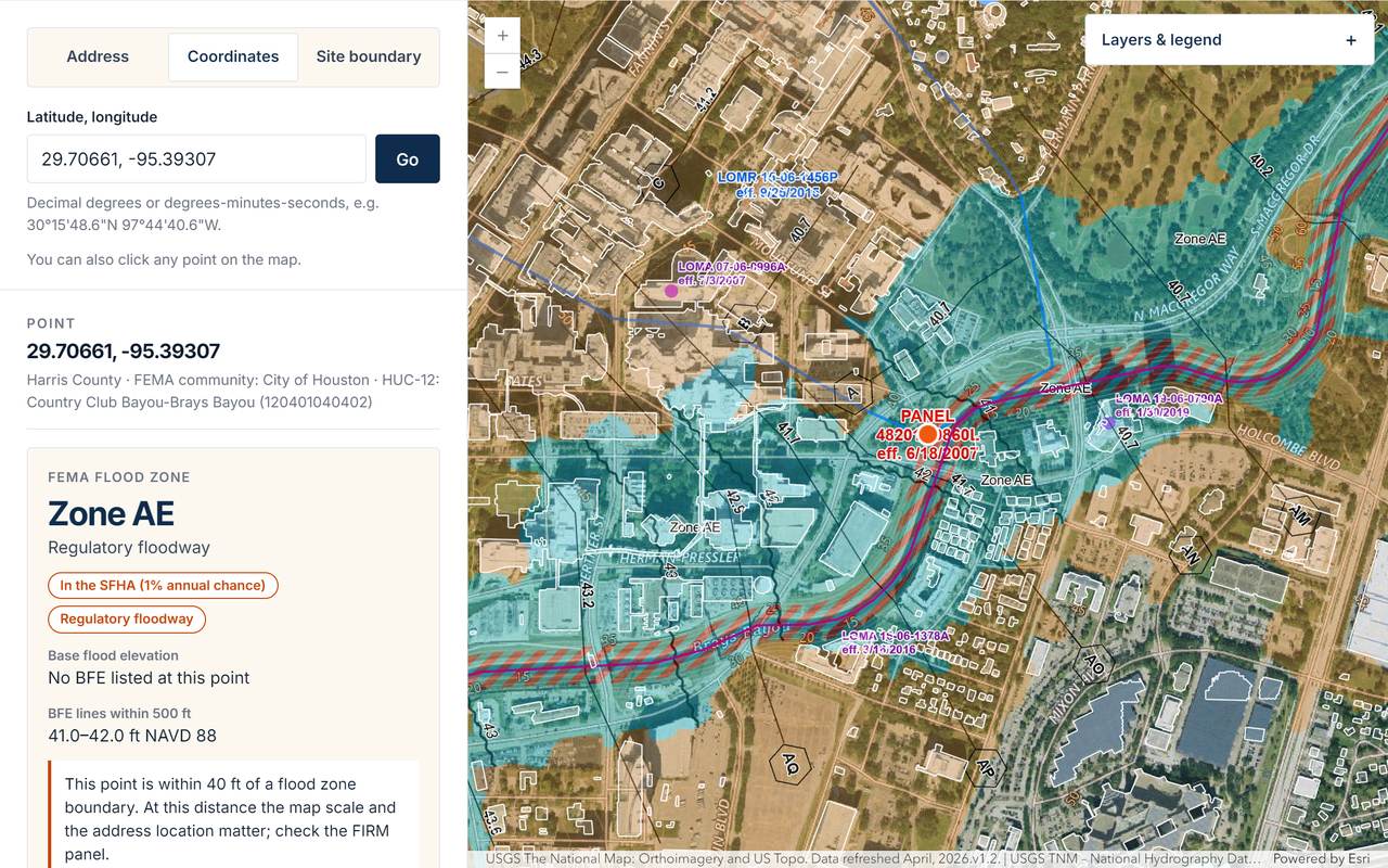
HERO E&C has launched the Texas Flood Screening Map, Texas's first free, statewide flood screening map that reports acres by FEMA flood zone for an uploaded site boundary. It runs in a web browser at heroenc.com/flood-map, with no account and no fee.
What it does
Start with a Texas address, a pair of coordinates, or a site boundary. A boundary can be drawn on the map or uploaded as a zipped shapefile, GeoJSON, or KML file of up to 2,000 acres.
For a location, the map reports the FEMA flood zone, whether the site is in the regulatory floodway, the base flood elevation (BFE) where FEMA has published one, the FIRM panel and its effective date, and nearby Letters of Map Revision and Letters of Map Amendment (LOMR/LOMA). It also shows building footprints, the nearest named stream and its HUC-12 watershed, and TCEQ Edwards Aquifer zones. Local notes flag places where city or county rules differ from FEMA.
For a boundary, it reports the acres and percent of the site in each flood zone, and counts the building footprints in the boundary and how many touch the Special Flood Hazard Area. Every result can be printed as a summary that lists each data source and the time it was checked.
Who it is for
The map is built for the people who need the flood-zone answer before anything else: drainage and site civil designers, surveyors, land developers, commercial real-estate professionals, and city and county staff who answer floodplain questions from the public.
Why we built it
In Dr. Seoyoung Kim's 20+ years of hydrology and hydraulics work, the opening question on almost every site was the same: what is the flood zone? Answering it well meant a GIS session — loading the effective FEMA data, checking the panel and its map changes, and measuring the site against each zone. The Texas Flood Screening Map puts that initial screening in a browser, free, with no account, so engineering time can go to the questions that need it.
An early look at a site should not wait for a GIS session. We put that screening in everyone's hands and kept engineering judgment where it belongs — with the engineer who studies the site.
— Dr. Seoyoung Kim, Ph.D., P.E., CFM · Chief Executive Officer, HERO E&C
What it is not
The map is a screening tool. It is not a flood zone determination, an Elevation Certificate, a LOMA, or a sealed engineering document. Preliminary and draft FEMA maps and local regulatory floodplains are not shown. Before a design, purchase, or permit decision, confirm the result with the FIRM panel and the local floodplain administrator.
Data and technology
Results come from public services: the FEMA National Flood Hazard Layer, FEMA USA Structures through Esri Living Atlas, the U.S. Geological Survey, the Texas Commission on Environmental Quality, and the U.S. Census Bureau geocoder for address search. The map is built with the ArcGIS Maps SDK for JavaScript. Every query runs from the visitor's browser directly to the public service; HERO E&C does not store addresses, boundaries, or results.
Try it on your next site
Open the map for any Texas site. When a project needs a site-specific drainage study, floodplain review, or FEMA map revision (CLOMR/LOMR), HERO E&C can help.